

Continuously evolving telecom technology
and intense competition necessitates

Efficient network planning and Rollout

Maximize Network utilization

Manintain High quality of services
Transform your fiber network rollouts with Genesys TeleSCAPE
TeleSCAPE is an indigenous product that brings a transformational shift in the way surveying and mapping data is analyzed in Telecom Industry, by using Panoramic Imagery, LiDAR Point Cloud, Geo-referenced maps and Geo-Tagged data sets along with Telecom Infrastructure. This greatly enhances the network planning, build and maintenance process, giving an accurate real world view of the ground situation, avoiding rework at the time of network build
•360 Degree Panoramic Imagery Viewing
•Network Assets and Map Overlay
•Map Navigation (Zoom/Pan)
•Add/Edit Network Element
•Measure Distance
•Data Analysis (Census/ Market/ Competition etc)
•Attach documents
•Integrate with Telecom Inventory Management System
•Import-Export Data
•Attribute Search & Edit
•Report generation capability
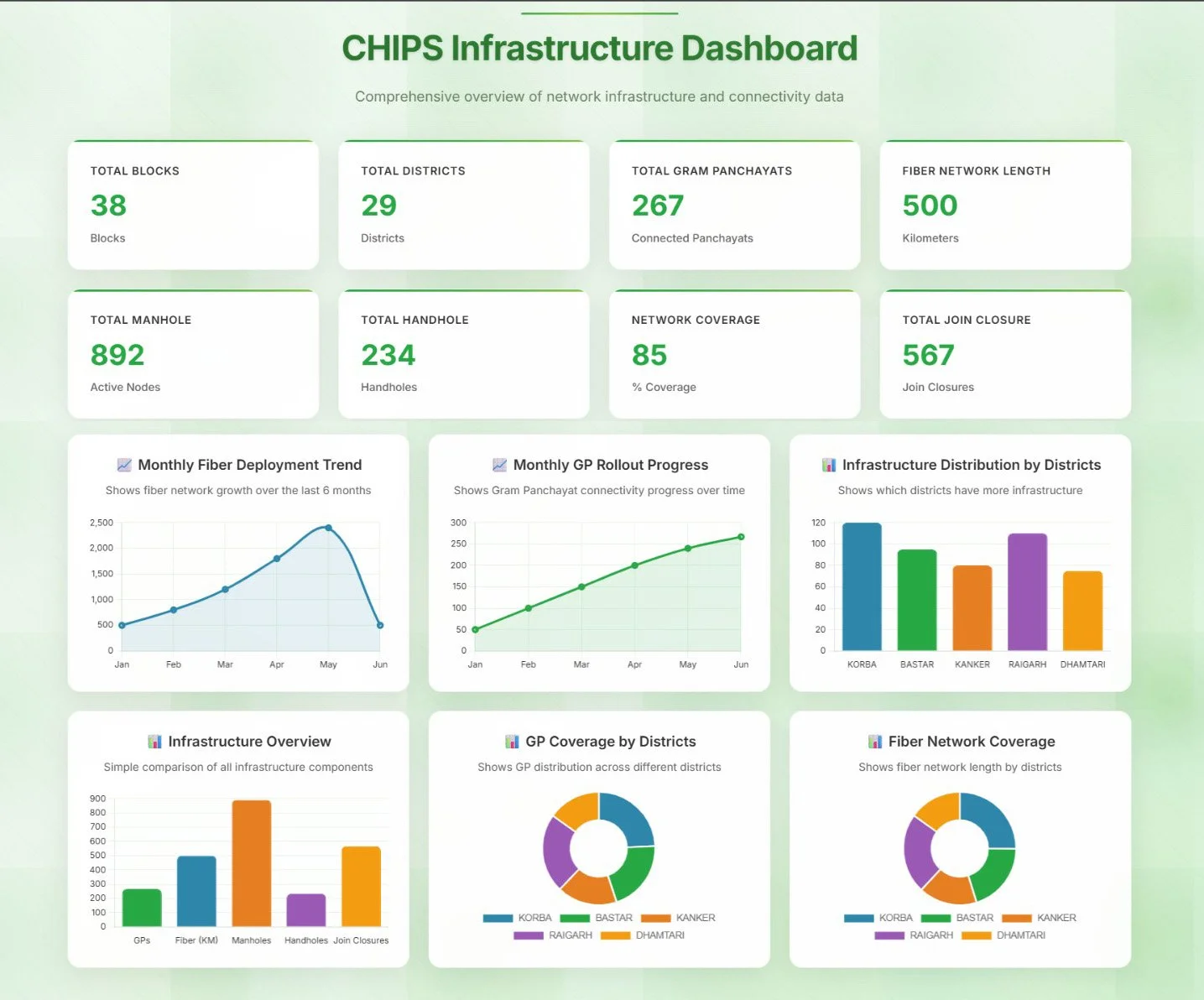
•Executive Dashboard
•Auto-Drive
•Entire Asset Inventory on a web based platform
•Customizable to suite different client needs.
•Enables the user to accurately measure lengths on map.
•Detailed route survey can be undertaken on a desktop based environment.
•Feature tagging both on site as well as in office highlighting deviations, faults, etc.
•Network Assets and Map Overlay
•Map Navigation (Zoom/Pan)
•Add/Edit Network Element
•Measure Distance
•Data Analysis (Census/ Market/ Competition etc)
•Attach documents
•Integrate with Telecom Inventory Management System
•Import-Export Data
•Attribute Search & Edit
•Auto-Drive
•Entire Asset Inventory on a web based platform
•Customizable to suite different client needs.
•Enables the user to accurately measure lengths on map.
•Detailed route survey can be undertaken on a desktop based environment.
•Feature tagging both on site as well as in office highlighting deviations, faults, etc.
•Report generation capability


Benefits of using TeleSCAPE
Desktop Survey
Planning efficiency
Build efficiency
Crew efficiency