

Genesys GIS Solution for Gas Network Modelling and Management provides a unique platform for Gas Distribution companies to digitalize their end-to-end network rollout process.

Gas Network & Asset Inventory
•Gas Network Model
•Network and asset inventory view
•Panoramic view to know the As-Is reality
•As built pipe line network
•Thematic view
•Pipe classified as per type/grade/size thickness etc
•Building classified as per usage residential, commercial etc
•Support for variety of maps - Google/Bing/OSM
•Area wise, Village wise, Charge area wise data display
•Common GIS functionality (Layer on/off, Pan, Zoom , Measure, etc)
•Integrated view for Customer Info, Asset health etc

Network Creation & Updates
•Pipeline locations and customer base information
•Directly tag asset on panoramic imagery
•Adding network elements
•Information of Assets, Features, Land marks, Customers
•Search Landmarks, Buildings, Asset, etc
•Search by Latitude, Longitude

Analysis & Reports
•Search & Filters
Pipeline by route name, area wise
Network type i.e. Steel/MDPE Pipeline
CGD Facilities like City Gate Station (CGS), Mother Station (MS), District Regulatory Station (DRS), Meter Regulatory Station, etc)(MRS), CNG Station etc.
•Reports in Excel , PDF & Other formats
•Impact of damage/fault on network, customer impacted
•Search landmark, customers & asset around a particular location within a given radius

Mobile App
•Field surveys
•Asset view, display layers
•Asset capture
•Attribute view
•As-built updates
•Report a problem
•Offline & Online mode
•Search & Query
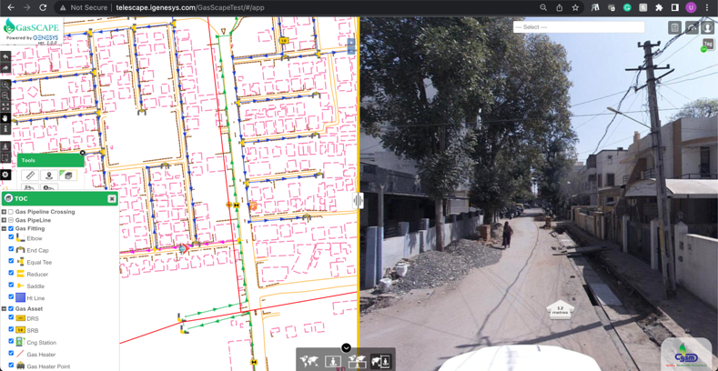
Basemap with 360° Panoramic view

As Build Drawing Integration

Asset Tagging on Panorama

Executive Dashboard

O & M - Fault detection and rerouting

Mobile App - Asset view, capture and edit, directly from field