

Challenges Faced by Fiber Providers
Planning inefficiencies and construction delays cost operators not only the time and money, but also the result in the lost credibility. Traditional methods of doing fiber planning and rollout are proving to be inefficient and every un-accounted deviation from plan, inaccurate ROW estimates, unforeseen obstructions or unexpected terrain encountered during network rollout process can have multi-fold impact on your rollout plans and budget.

Inaccurate
Planning

Frequent
Field Reworks

Delayed and Costly ROW

Long ROI
Genesys Offerings to Transform your Fiber Network Planning and Rollout
For last two decades, Genesys International has been providing geospatial services and solutions that have enabled Telecom Players in transforming and digitalizing their end to end Fiber Network Rollout process, specifically addressing the challenges faced by Operators. Our services encompass end to end lifecycle of fiber planning, rollout as well as operations. Genesys is a pioneer in using advanced geo-spatial technologies such as LiDAR and Digital Twins that greatly enhance the planning efficiency and accuracy.

Fiber Plan & Design Services

Fiber Solution
(TeleSCAPE)

GIS Data Services

Network Data Services
Fiber Plan and Design Service
Genesys service framework for fiber networks covers the entire lifecycle and is aimed at bringing accuracy, rollout efficiency and meeting your business targets, by use of industry best practices, geospatial technologies and products, decades of experience and our indigenous platforms.

LiDAR survey and mapping
Greenfield Survey and Corridor Mapping
Brownfield Survey
LiDAR and Panoramic imagery capture

Plan & Design
Route Feasibility Plan
Route Corridor Survey, Mobile Mapping
Digital Twin Creation & Desktop Survey
FTTx Planning

Build
Site Survey & Audits
Construction Monitor / Field Update
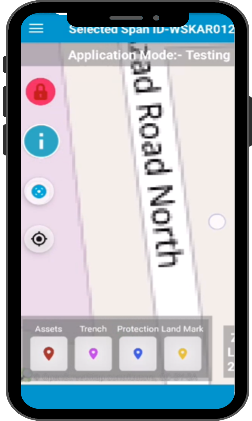
Telecom Grade Mobile Application
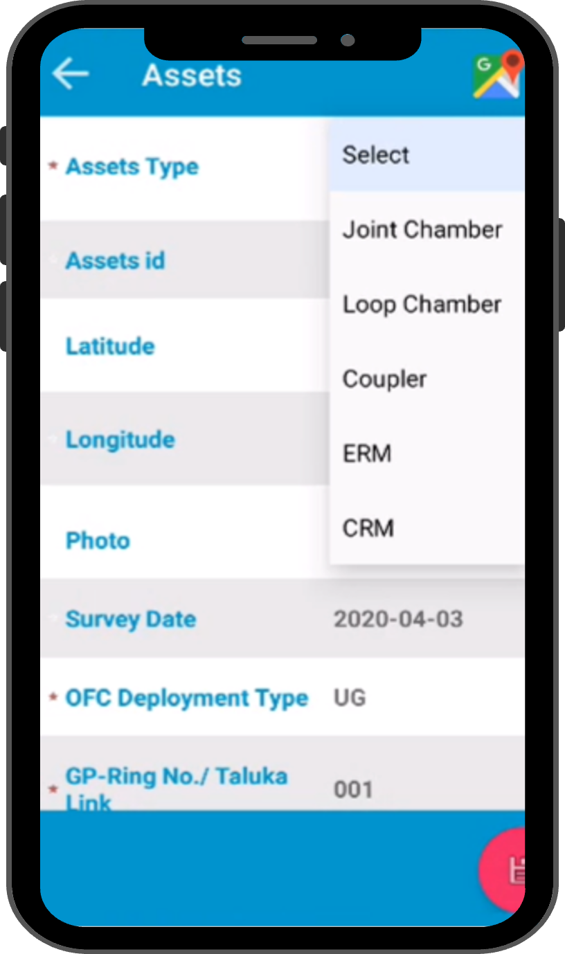
As-built Updates
Field Crew Management

Operate
Accurate As-Built Map
Existing Network Survey / Data Migration
Mobile Mapping / GIS Application
Feasibility, Serviceability checks
LiDAR Surveys and Mapping Services
•Mapping of entire corridor or the distribution area
•Detection and marking of utility poles and other assets
•Accurate dimensions
•Marking existing assets
•Road dimensions
•360⁰ panoramic imagery for true 3D representation
•Accurate assessment of obstructions, elevation, road surface type and degree of difficulty
•Facilitate precise planning and positioning of network elements
•Reduces the build-rework in the field

FTTx Plan and Design Services

•Analyse Customer Demand Points
•Creation of Clusters
•Civil Plan and Design: Trench, Duct, Poles etc.
•Overhead and Under Ground Route Planning
•Fiber Cable Planning
•OLT, Primary Splitters, Secondary Splitters and ONT Planning
•Network Capacity Planning
•High Rise and Low Rise Designs
•Detailed Design
•Schematics
•Bill of material, Cost Calculations
•Reports
•Quality Checks
•Automatic and Semi-Automatic FTTx planning
•Export to AutoCAD or any other standard GIS data format.
Construction Monitoring and As-Built Updates
•Brownfield Surveys for Network assets.
•Capture as-built locations of network elements of field
•Mobile App based updates from field
•Capture network build progress
•Geo-tagged photos
•Seamless synchronization
Network Operations

•Asset Survey
•Route Corridor & Asset Survey (DGPS Mobile LiDAR or 360 Panoramic)
•Customer Service Feasibility Checks
•Feasibility Reports
•As-built Updates
•Connectivity and Splicing
•Customer Circuits
GIS Data for Telecom
Genesys GIS Data Management services include creation and supply of wide range of high quality and updated spatial data sets to allow detailed and precise network planning and optimization tasks. Map data includes requisite details to allow wireless planners to improve predictions of signal attenuation, other radio propagation effects and assist in finding the optimal location of network base stations and other wireless system transmitters.
Our map data services also include a wide variety of data transformation services, including legacy data migration, integration and quality improvements.
Street view Panaromic Imagery
High Resolution 3D maps
Clutter Maps
DTM, DSM, DEM
LiDAR Point Cloud
Satellite Imagery
Customised Map Services
Map Data Transformation Services


Network Data Mangment Services
With decades of domain experience in handling Telecom Network Data, Genesys provides an array of services to handle your Telecom Network Geospatial Data. Objective of our data management service is to eliminate the telecom data silos and create a single source of truth for your OSS Data resulting in improved process efficiencies, network utilization and improvements to service levels.
•Legacy Data Conversion
•Sketch Vectorization
•As-built Vectorization
•OSP & ISP
•Format Conversions
•Address Sync
•Data Sync across OSS & BSS systems
•Data Governance
•Order Management
•Positional Accuracy
•Quality Checks
•Spatial and Logical integrity checks
Expertise on all leading GIS Platforms